
|
Navigate:VIRTUAL EXPLORATIONS > ARCHIVED EXPLORATIONS > ELYSIUM ARTISTS FOR THE ARCTIC
|
Part 13: Wednesday Evening, September 9Posted: Wednesday, September 9, 2015
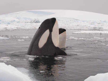
For much of this trip, we have been lucky enough to be invited to visit the bridge with the captain and crew when the ship is underway. Situated on the 6th deck, the 9 windows across the front and 3 on each side present one with a breathtaking view of what lies ahead. Many people took advantage of this view when we were looking for polar bears in the pack ice. Just after 6:00 p.m. today, as I was staring out from the bridge into the fog, when three large, black dorsal fins broke the surface just to the starboard of the bow. I said (or perhaps, yelled) “Whale! Whale! Orca!” The few people on the bridge were on the port side and most of them rushed to the starboard in time to see the three dorsal fins surface one more time and then disappear into the ocean. Click here for information on orcas. Right now, though, at 10:00 p.m. in the middle of the Atlantic Ocean, the bridge is quiet and I am the only visitor. It is fairly dark out now (as dark as the night has been for us), but I can still see the birds flying past the bridge and down over the bow of the ship without any need for deck lights. I can see the methodical rise and fall of the ship’s bow, a bit of ocean, and not far beyond that, the thick fog bank that we entered in mid-afternoon. The thick fog seems to surround us and, if not for the ships instruments, it would be hard to convince anyone that we were actually going anywhere. We are in the open ocean of the Atlantic and there are two things that help me know that. We certainly can’t see any land to help us out (remember it is a relatively dark and foggy night!), but we have GPS onboard (more than one) and the plankton in the collection we just did indicate we have indeed found North Atlantic water and have left the Arctic water that we have been exploring for the last 11 days. The GPS says we are at 74 02.680’ N, 6 42.573’ W — we crossed from east longitude to west longitude today and have set our clocks back an hour to adjust to Greenland time. The plankton community that was in tonight’s collection included Calanus finmarchicus — a copepod that is characteristic of the North Atlantic — and there was a lack of Calanus glacialis — a copepod with red antennae that is characteristic of the Arctic. These two species of copepods reliably stick to their preferred temperature of water, making them very good indicators of the type of water we are in. |
If you want a general idea of where in the North Atlantic we have traveled today, here are some GPS coordinates:
Time, Latitude, Longitude, Note:
8:38 a.m., 75 40.806’ N, 00 46.933’ E
10:39 a.m., 75 27.686’ N, 00 22.271’ W
12:22 p.m., 75 14.428’ N, 01 22.503’ W
6:03 p.m., 74 38.493’ N, 04 05.712’ W
6:10 p.m., orcas!
6:37 p.m., 74 34.185’ N, 04 25.111’ W
7:22 p.m., 74 28.529’ N, 04 50.624’ W
11:17 p.m., 74 02.680’ N, 06 42.573’ W
(Notes: These coordinates were taken when we were still on Longyearbyen, Svalbard time zone. The first two numbers of each latitude and longitude number are the degrees – I wasn’t sure if I inserted the degree symbol if it would translate to different fonts and make it through in the email, so I left it out.)
Related Features: Let's Speak Orca | Orca Reporting
Related Oceanscape Features:


|

|


|


|
